Team : Deekshith, Manoj, Shashi
Route : Bangalore
--> Mysore
--> Virajpet
--> Kakkabe (nearest bus station)
--> Tadiyandamol (~273km)
Transport : KSRTC bus, Bike ride
Trek distance : 5+kms (One way)
Trek timing : ~2.5hrs to reach peak, with couple of short breaks in between
Trek difficulty level : Moderate
Date of journey : 17 jun 2017
It was start of the rainy season and the wait is finally over for the monsoon trekking. This time we decided to explore a hill - Tadiyandamol.
About the Place:
Tadiandamol is the highest mountain of Kodagu district. Situated at a height of 1,750 meters above the sea level, it is the fourth highest peak in Karnataka after Mullayanagiri, Baba Budangiri and Kudremukha peaks.
The journey :
Two of my friends decided to travel by Bike, while I chose to travel by Bus. We started our journey at around 1:30pm from Bangalore. It almost took 6 hours for me to reach the last bus station called Kakkabe. From here I took a cab to reach the base of the hill, Nalknad Palace. By the time I reached this place, my friends had reached and were ready with the camp. As most of us were already tired by the long journey, we slept immediately after having light dinner.
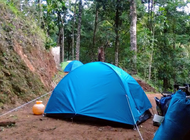 |
| Camping near the base of the hill |
Next day, we woke up early at 5:30am in the morning. We got freshened up, packed our tents and started to hike at 6:30 am.
 |
| Morning sunrise view |
Trekking :
Initial part of the trek was very easy. It was a metal road with the trees on either side of the path. Actual trek route begins after walking about 1km, and you will come across mud road.
 |
| Initial trek path |
 |
| Tall trees along side of the path |
 |
| Actual trekking begins from here |
 |
| Warning board : Overnight camping not allowed on the hill |
 |
| Trek path |
Second stage of the trail was moderate one, walking through open green grassland.
 |
| Open grass land |
 |
Fog covered route..
way to heaven |
Along the track, we witnessed some of the nature's beauty.
 |
| Snail |
 |
| Dew drops on leaves |
 |
| Spider web |
 |
| Green grass |
 |
| Umbrella shaped plant |
 |
| Forest flower |
Third phase of the trek involves moving through thick forest, known as Shola forest. This path was tricky with lots of thick tree roots on the surface. The trail through the forest was difficult one.
 |
| Shola forest |
It took almost 2.5hrs to reach the peak. The feel that we got after reaching the summit was unexplainable. Sun was playing hide and seek between the clouds and the clouds were in a race, chasing each other. The only possible sound that we could hear at this point was the gushing noise of the speedy wind.
 |
| At the peak |
After spending 30mins at the peak, we started to descend.
 |
| Time for some rest |
 |
| While scaling down |
As it was rainy season, we were attacked by leeches. We were already prepared with salt, Odomos and turmeric power. Thanks to Shashi for carrying these things to get rid of leeches.
The descend was much easier as expected. It took us ~1hr to reach the base of the hill.
 |
| Nature at its best |
 |
| Time lapsing |
By this time we were feeling damn hungry. We could not find any hotels nearby. We then traveled to nearest town Virajpet. It was almost 1pm when we reached Virjpet and we had our lunch. From here I took bus to Bangalore, while my friends continued to travel by bike. We reached Bangalore by 10PM.
As always, looking out eagerly for the next trek...


Awesome deekshith.!!
ReplyDeleteGood going. :)
ReplyDeleteNice... Time lapse is awesome
ReplyDeleteThank you all...
ReplyDelete